
Interdisciplinary Mission
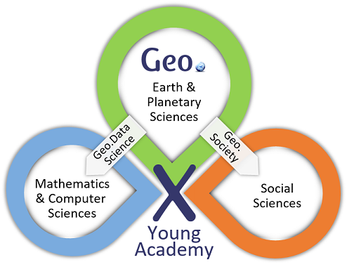
Geo.X creates a cohort of junior researchers who pursue research together in an interdisciplinary context.
In the second cohort of the Young Academy we deepen the scientific approach of Geo.Data Science. Data Science methods are ubiquitous in geoscientific research, whether in data measured by scientists in labs and field experiments or created by models. By combining such data in interdisciplinary projects, geoscience will gain insights into the system Earth and its relation to human habitat. Geo.Data Science aims at developing novel approaches for advanced data analysis at the intersection of mathematics and computer science with Earth sciences.
The thematic spectrum of the Young Academy is broadened with our new topic Geo.Society. Here, we will combine social science perspectives with our core geoscientific research fields to analyse the relations of geoscience with society. We focus on societal challenges that require the joint efforts of geoscientists and social scientists. These challenges include impacts of global environmental change, such as climate warming, land-use change, biodiversity loss, ecosystem change, air and water pollution, and related natural hazards, such as floods, landslides, earthquakes, and meteor impacts. Geo.Society will train a new generation of interdisciplinary scientists with geoscience and social science research skills that can interface both research fields.
Geoscientific Key Research Fields
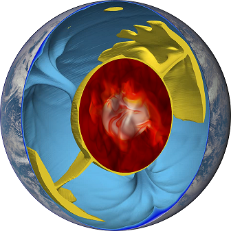
The evolution of planetary bodies is significantly driven by the forces acting inside them and the resulting mechanisms. They influence the shape, the gravity field and the rotation of the body, as well as deformations and formation of geological structures at the surface, and can also influence the development of the atmosphere through related volcanism.
With geodetic space techniques, the corresponding tectonic movements and deformations can be measured directly. Coupled with the mapping of gravitational and magnetic fields by space sensors, these data can provide relevant insights into geodynamic processes.
Although the terrestrial planets share many general properties regarding their origin, their chemical composition and their inner structure, they also differ substantially concerning certain characteristics. The investigation of the common features and differences (of the relevant geodynamic processes) also serves a deeper understanding of the special position of the Earth among the terrestrial planets, especially with regard to the development of habitability and natural hazards, such as meteorite impacts.
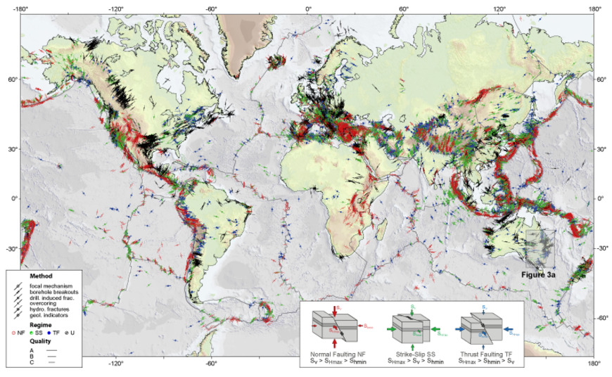
Natural Hazards and Risks occur at the interface between natural and societal processes, e.g. from the combination of hazard probability, exposure and vulnerability. In the last decades these aspects have been subject of major research efforts, because of their high societal relevance and their large uncertainty. Major scientific challenges are to better understand mechanisms of hazard development and vulnerability processes as well as to improve their predictability. In addition, the magnitude, frequency and impact of certain natural hazards are likely to change over time, because of, e.g., changes in the climate or other geophysical systems, increasing population at risk, or altered wealth.
Quantifying and managing hazards and risks, assessing their future developments and deriving risk reduction strategies in the appropriate spatial-temporal scales and resolutions, are currently among the most essential challenges in Earth sciences, and can best be addressed in an interdisciplinary network such as Geo.X. We focus on seismic, hydrological, geomorphological, atmospheric, and volcanic events in terrestrial systems of any region in the world. This may include cascades of different types of hazard and risk and conditions with complex interaction of anthropogenic activities and natural phenomena. We strive to push forward innovative early warning and prediction systems and develop new approaches using e.g., big data driven Earth observations, high spatial-temporal resolutions, data fusion for rapid event analysis, new smart technologies and coupled modeling.
The sustainable supply of georesources and their environmentally-responsible use in this and future generations is a key societal challenge. This is a traditional field for the geosciences and related geo-engineering disciplines, but today the topic of georesources is much more complex because (a) many of the "easy" near-surface and rich deposits of mineral and energy resources have been exhausted so future exploration must address deeply-buried, more diffuse deposits and/or more remote areas including the seabed; and (b) exploration and exploitation of resources requires broad societal acceptance, meaning that a balance must be found with the interests for land use, soil and water resources. Georesource research and development is a rapidly-growing, data-intensive and global activity. A key challenge and prerequisite for success is therefore the efficient use of new and existing information. Resource exploration programms rely on integration of extensive and diverse data sets from geology, geophysics, geochemistry and remote sensing; including innovative numerical tools and models for interpretation. To these must be added data sets and information on other aspects like climate, land use and population statistics that are needed by societal stakeholders and political decision-makers who must reach agreement on the conditions for resource extraction and use.
Investigations on bio-geological interactions in space and time enlarge our knowledge about how life is changing the environment of Planet Earth and how the Geosphere and the Biosphere interact. On one hand, the origin, evolution and distribution of life as well as biogeochemical cycling influence different processes within the Geosphere. On the other hand, geomorphological features, geological processes, climate dynamics, and geophysical conditions affect the Biosphere and are key elements of the past, present and future co-evolution of the Geo- and Biosphere on Earth. New ideas and innovative strategies are needed to investigate these complex interactions between the Biosphere and the Geosphere through big data synthesis and analysis across wide spatial and temporal scales ranging from DNA-level studies to plate tectonics. Results obtained by this interdisciplinary approach will also be of significance for the understanding of other terrestrial planets in space and the potential for life beyond Earth. The envisioned methods for this data-driven research enterprise are completely open and may include, but are not limited to: experimental approaches or model studies as well as in situ- or remote-sensing observations.
The societal research offers sustainable solution strategies for current and future generations. Since knowledge on these matters is widely dispersed in society, the research approach will, where appropriate, be transdisciplinary, i.e. include stakeholder and local knowledge.
Humans continuously interact with the geosphere. Human agency leads to global climate change, land use change or - more generally - changed states and flows in ecosystem services provided to humanity. Therefore, information on the human impact on Earth and how to transition to a more sustainable use of resources are among the core challenges at the cross-section of information sciences and geosciences. More complete datasets and models to monitor ongoing changes, to illustrate future mitigation and transitional adaptation pathways related to climate change are urgently needed. Modelling and monitoring of global land cover and land use change needs substantial advancement. A prerequisite for such novel information is the integration of big data related approaches. In the domain of "Human habitat and sustainability" Geo.X therefore explicitly addresses information needs related to climate change modelling and land cover and land use change analyses based on satellite data and other big data domains.
Managing these challenges also requires understanding the role and politics of geoscientific knowledge in controversies surrounding these issues, stakeholder reactions in past events as well as according governance challenges, which will be addressed by the social sciences.
Methodological Research Areas in Data Science
One of the central challenges for the geosciences in the 21st century arises from the necessity to quantify uncertainty in any scientific conclusions we draw from computer simulations and available observational data. Uncertainty quantification relies on a probabilistic interpretation of all involved quantities and requires advanced mathematical tools from statistics, the theory of stochastic processes, scientific computing, and machine learning.
At the same time, it is important that these tools are being considered against the background of specific applications from the geosciences in order to result in computationally tractable and robust algorithms and analytic techniques. Research areas within uncertainty quantification with particular relevance to the geosciences include data assimilation, stochastic parametrizations, multi-scale analysis, model reduction, sensitivity analysis, stochastic Galerkin and non-intrusive, approximation methods, statistical inverse problems, and optimization techniques.
The evolution of complex Geo-Systems quite generally involves interactions of many individual subprocesses and mechanisms across a range of length and time scales. A substantial portfolio of methods and techniques from modern applied mathematics is available today that supports the development of an in-depth understanding of such systems. This includes homogenization techniques, asymptotic multiscale analysis, and stochastics. Possible targets of research in this area may come from atmosphere-ocean science, climate research, and Geophysics as much as from climate impact research dealing with links between the society and the environment.
Given the sometimes overwhelming complexity of systems of interest in the geo- and climate sciences, computational simulation is often the most viable approach to developing modelling and prediction capabilities. Scientifically sound computation-based research calls for solid knowledge of numerical mathematics and related computer science techniques, combined with a good understanding of the applied geo-science issues and language(s).
With ever increasing precision capability of measuring devices, as well as the multiplication of data sources, come increased expectations about the amount of information that scientists will be able to extract from the mass of collected data: the geosciences find themselves at the forefront of that trend. While fundamental statistical questions such as assessing signal from noise are more than ever current, they come with new significant challenges due to the huge size of these new data, both in dimensionality (number of variables) and size (number of observations). Traditional approaches undergo severe limitations both due to intrinsic statistical limits (the so-called "curse of dimensionality") as well as computational bottlenecks. Modern statistical methods try to tackle those issues simultaneously by introducing innovating point of views and techniques, which should be further developed to meet the needs rooted in specific geosciences applications. Particularly relevant themes include dimensionality reduction, computational resource sparing approximations, inference of low-dimensional structures (such as manifolds, sparse and low-rank representations), statistics of networks, variable and model selection, resampling methods, iterative methods and regularization methods.
Data Integration is the process of unifying datasets from disparate sources. The goal is to build automated systems that combines datasets efficiently into a complete, correct, and useful target schema. Typical steps in the data integration pipeline are data extraction, data cleaning, data transformation, and entity resolution. Building appropriate wrapper-mediator architectures and designing efficient data transformation and cleaning algorithms are key challenges in data integration. In the realm of geosciences, data collected from dynamic geophysical remote sensors sensors and other static data sources have to be appropriately integrated before the actual knowledge generation and data analytics can take place.
Data Profiling is the process of generating meta-data, such as statistics, summaries and dependencies from one or multiple datasets. The results of data profiling algorithms can support the decision process in data integration, data management, feature engineering, and data analysis. Considering the velocity of data produced by geophysical remote sensors, new challenges include the adaptation of existing profiling techniques on relational data to data streams.
Many interesting research problems in the geosciences can only be tackled by the use of a multitude of different data sources. These are typically distributed over various sites, exhibit highly heterogeneous structure, format and semantics, and provide their data in various scales and granularities. Providing integrated, up-to-date and semantically homogeneous views on such data sources is a difficult problem, requiring a mixture of techniques from research fields like databases, statistics, and semantic web technologies. Heterogeneous data sources are particularly challenging when data is are very large or changes content very rapidly.
Methodological Research Areas in Social Sciences
The environmental systems studied through geoscientific research methods are intimately linked with human systems; via human interventions and environmental impacts felt by humans, but also fundamentally in the way we ascribe meaning to our environment. This interrelation of human-environment (or social-ecological) systems calls for a mixed methods approach to understanding these interlinkages; mixed in the sense of social-ecological, qualitative-quantitative, and interpretative-predictive research. It also calls for scale-bridging research addressing our knowledge gaps in how geoscientific processes interact with social processes across local to global scales and over short to long timescales. Among the key concerns are livelihoods in highly sensitive landscapes. Communities living in landscapes sensitive to natural disasters and climate warming must adapt to rapidly changing conditions. Natural hazards as well as climate and ecosystem changes threaten livelihoods and basic functions of existence such as infrastructure, food, and water supply. Among those most intensely affected are local communities and social groups with close relationships to land and the natural environment. Addressing these challenges requires comprehensive assessments of the dynamic interactions of physical, social and economic drivers of change, at times together with stakeholders.
One domain of geoscience is numerical modelling, e.g. of impacts of climate change and natural hazards, either for making projections or gaining insights into the modelled system. With the recognition of coupled social-ecological systems, treating humans as mere boundary conditions of models is increasingly seen as insufficient for adequately describing these complex systems. Hence efforts are under way to capture the intricate feedbacks between environment and human systems through coupled geo/social science models. Current research gaps include uncertainties in these models, and conceptions and quantifications of “the social” in these models, which are in the domain of the social sciences. Key areas of application for coupled geo/social models are the impacts of natural hazards and climate change on human livelihoods and basic functions of existence. Impacts of natural hazards often result in complex and unforeseeable responses in communities. The development of risk management plans and climate change adaptation measures thus have to deal with high uncertainties. Remote sensing and new types of data offer potential for innovation. Combining geoscientific modelling with social, demographic or economic modelling and big data analysis approaches can create novel tools to reduce uncertainties in risk assessments and climate change impact studies. Visualization of uncertainty is an additional challenge to be addressed here. Among the new data sources are open data like OpenStreetMap, social media, crowd sourcing, and GPS tracks. Data-driven techniques (e.g. machine learning, data mining) bridge to Geo.X’s successful research strand “Geo.Data Science”.
Among the aforementioned challenges is the assessment of risks, such as natural hazards and climate change impacts, which is important to support decision-making. Some of these risks are exogenous, like earthquakes and meteorites, while others arise from the intrinsic coupling of human-environment systems. Particularly challenging are multi-hazard risk assessments, where natural and anthropogenic hazards may interact in cascading or compound events, or where vulnerability changes within or between events. Social science knowledge is necessary for the development of a comprehensive picture of the resulting damage, which in addition to direct damage should include indirect damage (e.g. due to disruptions of supply chains) and intangible damage (e.g. health and psychological distress, environmental and cultural damage). Moreover, human interventions have significant influence on all components of risk, i.e. hazard (e.g. flood hazard reduction via dike construction), exposure (e.g. land use change), and vulnerability (e.g. private precaution and preparedness). Information on how human behaviour and practice influences hazards, exposures, vulnerabilities, and resulting impacts, as well as the recovery processes after shocks, can be provided by economic, human geographical, and ethnographic research. Policy-orientated research can provide input to the appropriate political interventions and legal frameworks to manage risks and their components at various scales. Finally, we need to develop instruments for communicating hazards, risks, and management options and evaluate the effectiveness of such communication.
Another key challenge is natural resource management. The geosciences generate a plethora of information on our endowment with natural resources, such as air, water, land, biomass, and minerals and the processes of their degradation and regeneration. On the one hand, how human action causes changes in resource availability, renewal, and degradation and interrelates with other drivers of global environmental change is an area of coupled geo/social science research in itself. On the other hand, the information that this research provides is vital for the equitable management of natural resources, now and with respect to future generations. In order to address issues of fair distribution, democratic engagement, and sustainable management, geoscientists need to collaborate with experts in governance and decision-making on various scales (local, national, international), including legal scholars and political scientists, economists (valuing resources in material and immaterial terms), and sociologists and anthropologists. In situations of high uncertainty and value disagreement, it can move an issue forward if those for whom the resources in question are a matter of concern co-develop and deliberate policy options in tandem with geoscientific analysis.
The production and uptake of geoscientific knowledge and technologies are also always social processes in space and time. On the production side, geoscientific knowledge and technologies build on specific epistemic, geopolitical, cultural, and economic conditions and traditions and have co-evolved with an array of instruments and techniques, from the rock hammer to the satellite. The social settings of knowledge production can be approached as networks and belief systems, for example through ethnographic studies. Many of the key objects and terms of geoscience have corollaries in the social and cultural sciences: space, place, scale, region, structure, map, field, uncertainty, data, measurement, infrastructure, standards, and many others have been the focus of studies concerned with understanding how they function in specific practices and what they mean in and for specific situations and decisions. Ethnographic research dedicated to studying the material and discursive (everyday) practices of geoscience contributes to understanding and dealing with the transferability and specificity of geoscientific knowledge while helping to translate this for different contexts and communities. On the uptake side, geoscientific knowledge and technologies are understood as part of larger social contexts. How new science and technology is welcomed or rejected by society depends on cultural commitments within political communities, national and international legal and political regimes, and changing media landscapes, among other factors. To help make sense of their purchase and limits in broader society, both the production and uptake of geoscientific knowledge and technology need to be understood within the epistemic, moral, cultural, and political landscapes that shape them, and which they in turn shape. This brings into focus who may benefit from and who may be disadvantaged by certain prevailing geoscientific knowledge and technologies when these are contested, overtly or not, by alternative perspectives, frames, and knowledges.
The geosciences provide knowledge and technology on important societal challenges, including climate change, natural hazards, rapid urbanisation, and natural resource distribution and use. It is often unknown, however, how and with what effect this knowledge and technology find their way into policy and practice, and support accountable, democratic, and effective decision-making and implementation. Impact assessments and social learning studies running alongside geoscience projects can investigate their economic and wider societal costs and benefits, elucidate sustainable pathways, and inform effective knowledge exchange and communication of risks and uncertainties. Where geoscientific research practices, resulting knowledge, and related policy processes are controversial or break with long-standing conventions, new transdisciplinary approaches are called for, e.g. co-creation studies and multi-stakeholder processes aiming for mutual learning and decision-making. The very questions of what constitutes good research practice, sound and sufficient knowledge, and fair and just policy are central for the dialogue with societal actors, institutions, and publics. This transdisciplinary research approach will benefit from new social media data and uses, geographical information provided by volunteers, and Citizen Science endeavours.